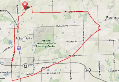
 Matt met me at my house and we rode south a few miles to meet up with the Clinton River Trail. We followed the trail all the way up into Rochester and stopped for a beer and a sandwich. Had two more beers and then rode home in the dark, this time, taking the more direct way. Here's the GPS.
Total Distance: 19.23 mi
Elevation Gain: 796 ft
Ave Speed: 12.6 mph
Max Speed: 25.0 mph

2 comments:
noice!
How was traffic on the lower half of Opdyke? Looks like a substantive thoroughfare!
Opdyke was fine, there is a bike lane that comes and goes but i wouldnt want to do it during rush hour. Crossing the bridge over M59 was intimidating.
Post a Comment